West Rim Trail
|
The 30.5-mile West Rim Trail (WRT) follows the edge of the scenic Pine Creek Gorge in Tioga and Lycoming Counties, and offers dozens of spectacular vistas, many of which are more than 1,000 feet above the bottom of the gorge.
The WRT also heads inland several times to traverse rugged side hollows, visiting scenic side streams in the process. It also passes through Colton Point State Park. |
|
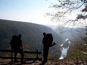 One of the many vistas of Pine Creek Gorge
The northern terminus of the WRT is near the village of Ansonia, via a forestry road just south of US 6. The southern terminus is on PA 414 near the village of Blackwell. Above Blackwell, the hiker can use the scenic Bohen Falls Trail to descend to the bottom of the gorge, walk through the village, and connect to the Mid State Trail.
The WRT is described in the point-by-point Guide to the West Rim Trail by Chuck Dillon (2015), which can be purchased online from Pine Creek Outfitters.